Google's Street View has allowed us to visit some truly amazing places over the years - including, most recently, the TARDIS.
But its latest project will shock the world. Get ready for... Canal View.
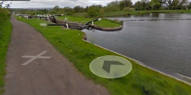
That's right. Google is about to loan out its Trekker wearable backpack to the Canal & River Trust, who will use it to capture footage of some of most scenic parts of England and Wales's 200-year old waterway network. The idea is to open up its canals, rivers and towpaths to millions of people worldwide.
Google Trekker uses a 4ft, 40lb backpack fitted with a 15-angle lens camera to take 360-degree pictures every 2.5 seconds in public places that the Street View cars and Trike cannot get to, with the images added to Street View on Google Maps.
It is the first time the technology has been on loan in the UK.
The trust, which manages England and Wales's waterway network, will begin at Regent's Canal in London and aims to walk the Trekker more than 100 miles over the next month to capture locations such as canal tunnels, locks and villages.
It wants to record imagery of the three-and-a-quarter mile Standedge Tunnel in Yorkshire, the longest and deepest canal tunnel in the country and Bingley five-rise lock, on the Leeds and Liverpool Canal, the steepest lock flight on the network.
Shots will also be taken of the blacksmith's workshop at picturesque Stoke Bruene village on the Grand Union Canal, among other places, the trust said.

153 Amazing Google Street View Pictures
Wendy Hawk, partnerships manager of the Canal & River Trust, said:
"We're delighted to be the first people in the UK to get the Trekker on our backs - it's fantastic that our 200-year old network is being given a different lease of life thanks to cutting-edge 21st century technology.
"The footage we get will allow millions of people from all over the world to see our canals, rivers and towpaths and will hopefully encourage some people to make a trip to see them."
Google's Pascale Milite said: "We are thrilled to be collaborating with the Canal & River Trust on such a fun project, and we hope to help boost the discovery of and make these historic canals more accessible to more people in the UK and across the world through Street View technology."
Google Trike has already mapped some of England and Wales's most dramatic waterway scenery, capturing Caen Hill lock flight in Wiltshire and the Grade I-listed World Heritage Site around Pontycysyllte Aqueduct in North Wales last year.