
If Hurricane Florence was a slow-motion train wreck, Hurricane Michael is a 4-ton wrecking ball.
As Florence made its way toward the coast of the Carolinas last month, it weakened from a Category 4 to a Category 1 storm with sustained winds of 90 mph. It gradually slowed to a sluggish pace of 5 mph.
Experts warned of significant damage along the coast, but stressed that the bigger threat was “catastrophic flash flooding.” After making landfall near Wilmington, North Carolina, on Sept. 14, Florence stalled, dumping as much as 35 inches of rain in some areas over the course of several days. Large portions of North and South Carolina experienced devastating flooding. At least 51 people were killed.
Michael has proven itself a very different beast. Fueled in part by above-average water temperatures in the Gulf of Mexico, the storm rapidly intensified at the start of this week. It strengthened from a tropical storm on Sunday to a Category 1 hurricane with 75-mph winds on Monday.
“This one really snuck up on everyone,” meteorologist Jaclyn Whittal tweeted on Monday.
Ari Sarsalari, a meteorologist at The Weather Channel, said Tuesday that Michael would be “an absolute buzzsaw.”
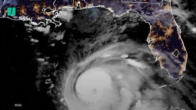
By Tuesday, Michael had reached Category 2 strength. And on Wednesday afternoon, it slammed into the Florida coast as a major Category 4 storm with maximum sustained winds of 155 mph ― just 2 mph shy of Category 5 strength.
Upon making landfall near Mexico Beach, Florida, Michael was moving at 14 mph ― more than double Florence’s speed at landfall.
Marshall Shepherd, director of the atmospheric sciences program at the University of Georgia and a former president of the American Meteorological Society, told HuffPost via email that the lesson from Florence and Michael is that “no two storms are alike.”
“They can be dangerous for very different reasons so focus on impacts not category,” he wrote.
Sheppard said the major threats from Michael are high winds and storm surge, forecast to reach 14 feet in some coastal areas. But heavy rain could trigger “life-threatening flash floods” in the Florida Panhandle, southeastern Alabama, Georgia, the Carolinas, and southern Virginia as the storm moves to the northeast, according to the National Hurricane Center. Some areas could see as much as 12 inches of rain.
The storm is expected to affect many communities in the Carolinas still reeling from Hurricane Florence. North Carolina Gov. Roy Cooper (D) declared a state of emergency Wednesday morning in 66 counties.
“North Carolina is staring down another powerful hurricane less than a month (after) Hurricane Florence battered our state,” Cooper said at a news conference, The News & Observer reported.
Meteorologists offered stark warnings ahead of Wednesday’s landfall.