
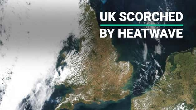
Satellite imagery taken months apart has revealed the stark effect the recent heatwave has had on England.
The remarkable images, taken in early May and mid July respectively, show a marked change from a deep green to a scorched brown as the lack of rain and sunny weather took hold.
June ranked as one of the top five warmest on record (since 1910) with the UK receiving less than half the average rainfall expected.

England in particular received less then a quarter of its predicted rainfall in June.
Counties such as Essex had 1.7 mm of rainfall (4% of average), Dorset 2.0 mm (4% of average) and Middlesex only 0.7 mm (2% of average) making it provisionally the driest on record, according to the Met Office.
This lack of water has also carried on over into July and is expected to continue well into August, prompting a hosepipe ban in the northwest of England (the first in the country since 2012). The suspension, which comes into place on 5 August, follows a ban already implemented in Northern Ireland amid the longest heatwave since 1976.

Martin Padley, United Utilities Water Services Director, said: “Despite some recent rainfall, reservoir levels are still lower than we would expect at this time of year and, with forecasters predicting a return to hot, dry weather for the rest of July, we are now at a point where we will need to impose some temporary restrictions on customers.”
Of course it hasn’t been completely dry, along with the heat July saw the arrival of humid thunderstorms that hit parts of Wales and the west coast.
With the ground so dry however, much of the water will run off the ground, causing small isolated patches of flash flooding.

If you’re wondering when this hot weather will end we’ve got some bad news. It’s expected that another thunderstorm will hit the UK at the end of the week however those high temperatures will remain.
In fact, it’s expected to get even hotter with Sunday and Monday seeing temperatures rise to a scorching 29 degrees in some areas.