It’s January, it’s bleak, it’s frigidly cold – so it must be time to roll out the thundersnow.
Most of Scotland and the northern half of Britain are currently being treated to a rare weather phenomenon in which thunderstorms occur with snow rather than rain.
Thundersnow is caused in the same way thunder and lightning are triggered during the warmer months, when a pocket of warm air at ground level rises and collides with the colder air above it.

Even if temperatures are freezing or in the minus figures, the air above it is significantly cooler. In the summer months, this process creates heavy rain showers and lightning storms. In the cooler winter months, the country is pelted with snow instead.
Windward coasts will be particularly affected, as are higher elevations and upland areas including the West Highlands and Fort William.
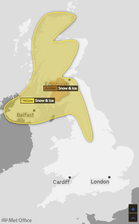
Amber snow and ice warnings are in place over central Scotland including Edinburgh until 10pm on Friday.
Heavy, frequent thundersnow will continue on and off throughout the day and travel delays on roads are likely, as are public transport cancellations. There is also a chance of power cuts and mobile phone coverage being affected.
Yellow snow and ice warnings stretch the length of Scotland until around midnight on Friday, with snow showers affecting the North West of the UK, often falling as sleet and hail near coastal areas.
Yellow warnings are also in place for Saturday, covering most of Northern Ireland, Scotland, through to the West Midlands and Yorkshire & Humber. Ice, sleet and snow showers, leaving up to 3cm in places are expected. Come Sunday, the warning area will slip south to take in the East Midlands too.
But the news isn’t all bad. A warm front will be pushing across the UK between now and Sunday, though the mercury will begin creeping up into double figures, its collision with the cold air could cause further thundersnow in west Wales and the Home Counties.
Friday will see highs of 7- 8C in south east England, while on Saturday Plymouth could see temperatures of up to 11C.
Sunday could nudge it up to 12C, signaling we’re warming up… for now.

