Network Rail has activated “extreme weather action teams” as it prepares for possible disruption to train services due to the scorching heatwave across the UK.
Large swathes of Britain have experienced storms and lightning strikes overnight and the country is bracing for what could be its hottest day ever later this week.
Network Rail has said speed restrictions could be in place for the hottest parts of the country and in severe circumstances, buckling of the steel tracks could cause some lines to close.
Nick King, network services director at Network Rail said: “Keeping passengers safe and moving are our top priorities during this heatwave.
“That’s why we sometimes have to put speed restriction on to prevent our rails - that can be over 20 degrees hotter than air temperatures - from buckling which can derail a train and cause huge delays.”
Anyone using the train network this week is advised to regularly check their train operator’s website or National Rail Enquiries.
Thunderstorms moved into southern and western areas late on Tuesday evening, with the Met Office issuing a yellow severe weather warning for most of England, Wales and Scotland until 9am on Wednesday.
The Met Office has issued weather warnings for overnight Thursday into Friday, cautioning of thunderstorms and lightning strikes which could cause power cuts and flooding.
The warning is for most of England, except the South West, and parts of Scotland.
North Wales was the wettest area overnight, getting 15mm of rain in one hour.
But by Wednesday morning, much of the country was already experiencing temperatures far above normal for this time of year.
“Quite a lot of places are back up to 23 or 24 degrees already (at 5am),” Met Office meteorologist Emma Smith said.
“It’s normally 13 or 14 degrees at this time of year, so that’s 10 degrees above average.”

It comes after temperatures across England exceeded 30C (86F) on Tuesday, with forecasters predicting even hotter temperatures on Wednesday.
“It will get to 35 degrees on Wednesday, with a small chance it will get to 36C,” said Smith.
The highest overnight average temperature ever seen in the UK was 23.3C (73.94F) in July 1948.
Smith said there is a possibility this will be beaten on Thursday night into Friday.
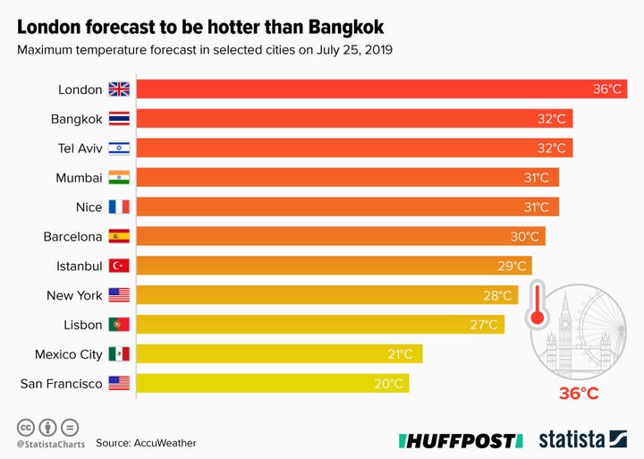
Temperatures in London are expected to reach 38C (100.4F) on Thursday, which would pass the current record for a day in July – 36.7C (98.1F) – recorded at Heathrow Airport in 2015.
The Met Office said there is a 40% chance the UK temperature record of 38.5C (101.3F), which was recorded in Faversham, Kent, in August 2003, will be exceeded.
Northern Ireland and western Scotland will be the coolest areas on Thursday, with temperatures in the low 20s.
Train company Southeastern said it would be running a “significantly reduced service” on Thursday due to speed restrictions announced by Network Rail.
Southeastern operates trains in south-east London and Kent and also serves parts of East Sussex.
Dr Sam Hampton, a post-doctoral research associate at the Environmental Change Institute, University of Oxford, advised people to wear “lighter, loose-fitting clothing before cranking up the air conditioner”, adding that: “If necessary, air-conditioners should only be run when all the windows are closed.”
In London, police were searching for three people who have gone missing in the River Thames.
The Metropolitan Police said a swimmer went missing at Shadwell Basin on Tuesday evening, a second at Waterloo Bridge and a third near Kingston High Street.
